ERG knows environmental laws and regulations. Working with local, state, and federal customers, we conduct compliance evaluations, develop environmental management systems (EMS), and maintain compliance in plans, permits and other regulatory activities. And we do all of that with an eye toward sustainability and minimizing environmental impact.


ERG tailors on-site services to the project and customer. These include environmental assessments, remediation, monitoring, and compliance activities. In addition, we sample soil and water, offer environmental site assessments, remediate contaminated sites, and implement environmental management plans. Throughout project lifecycles, ERG staff ensure adherence to environmental regulations, management of environmental risks, and implementation of sustainable practices.
Our customers aren’t just getting on-site employees—they’re engaging a team of support staff whose number one job is customer happiness. This support is outlined below.
-
For each on-site position needed, ERG conducts a comprehensive search, identifying highly qualified candidates who also fit the ERG values of integrity, sustainability, and commitment.
-
Once employees are on site, we ensure their integration into the site’s workplace and ERG. An online community allows our on-site employees to share information and exchange ideas. This value-added resource enables synergistic relationships among all employees and fosters quality deliverables across the entire company.
-
Employees should focus on the work they were hired to do, not company benefit problems. That’s why we take extraordinary care of employee concerns. We fund a robust healthcare program and offer retirement matching, as well as parental leave and family medical leave. We are committed to answering employee benefit questions and resolving issues quickly and efficiently.
-
Employee supervision and management are ongoing and consistent. ERG constantly reviews and improves employee performance, making the employee a better person and enhancing mission performance for ERG customers.
-
Our support extends beyond on-site employees. Customers are encouraged to tap into the collective skills, experience, knowledge, and out-of-the-box thinking of all of ERG.
-
For more than twenty years, we have been in the environmental contracting industry, speaking the language of our customers. Mission components do not need to be translated to ensure that work gets done efficiently, well, and on time.


Data Compliance, Classification & Standardization
Ensure consistency and compliance with our data classification and standardization services. We refine your data to meet all specifications and schema requirements.

Data Analysis & Geographical Data Processing
Unlock the power of data with our comprehensive analysis services. From soil and drainage studies to vegetation assessments and hydrology, we turn raw data into actionable insights. Ideal for environmental monitoring, predictive modeling, and heritage site management.
Virtual Exhibits & Public Outreach Consulting Services
Being good stewards of our world means more than just getting projects completed. Make history come alive with our virtual exhibit services! We create engaging digital displays and multimedia experiences and offer advice on public-friendly themes, content, and design for on-site static displays and virtual exhibits. Perfect for showcasing archaeology, history, and environmental projects to the public.
Digitization and 3D Scanning
Dive into the future (or bring your past) with our top-notch digitization services! Whether it's archival or administrative paper records, individual artifacts, buildings, or entire landscapes, we use cutting-edge tech like Digital SLR large-format scanning, terrestrial LiDAR, and photogrammetry to bring your projects to life. Perfect for standalone projects or as a complement to other initiatives such as public outreach.
Small Un-piloted Aircraft Systems, Aerial Imagery and Videography
Elevate your project perspectives with our sUAS/drone services. Our FAA-certified pilots safely and efficiently capture high-quality aerial imagery that enhances 3D modeling, orthoimagery, as well as field logistics and site documentation.
Report Automation
Report Automation
Save time with our custom report automation tools. We use Python scripts, PowerBI, Adobe, and more to streamline your geographic and data reporting tasks.
Dashboards and Data Viewers
Simplify decision-making with our interactive dashboards and data viewers. Get intuitive, dynamic insights into your project's data at a glance.
High-Precision Mapping and Geographical Documentation
When accuracy matters, our high-precision mapping services deliver. Using RTK, GNSS, and real-time aerial ortho-mapping, we provide detailed geographical documentation that you can rely on.
Digital Field Data Collection
Streamline your data collection with our digital solutions. We configure Field Maps and Survey123 applications to ensure efficient and accurate data collection for environmental surveys. Customizable to meet your project's specific needs.
Constraints Mapping and Fatal Flaw Analysis
Avoid project delays with our constraints mapping and fatal flaw analysis. We assemble terabytes of environmental and cultural data and use it to identify potential pitfalls early, helping you plan for and navigate project permitting with ease.

Technology & Innovation Services
Technology & Innovation Projects


Corpus Christi, TX
Gault Aviation Hangar Project - On behalf of Garver USA and the Corpus Christi International Airport (CCIA), Environmental Research Group, LLC (ERG) evaluated the Gault Aviation Hangar (1961) at CCIA in Nueces County, Texas. ERG’s architectural historians evaluated the distinct Googie-style hangar for its potential eligibility for listing in the National Register of Historic Places (NRHP) under the National Historic Preservation Act of 1966 (NHPA). The project involved developing a Memorandum of Agreement (MOA) with the Texas Historical Commission (THC) and thorough documentation to mitigate for the building’s demolition. To mitigate the impact, the THC requested thorough documentation.
ERG took large-format photographs of the structure before demolition and developed a three-dimensional digital building model for public display and for permanent archiving, the first such project of this kind. Our GIS team compiled aerial imagery captured with automated sUAS/drone missions and terrestrial photography captured with hand-held cameras to create a 3D model as part of the historic mitigation using photogrammetry workflows. Hangar One - Corpus Christi International Airport.
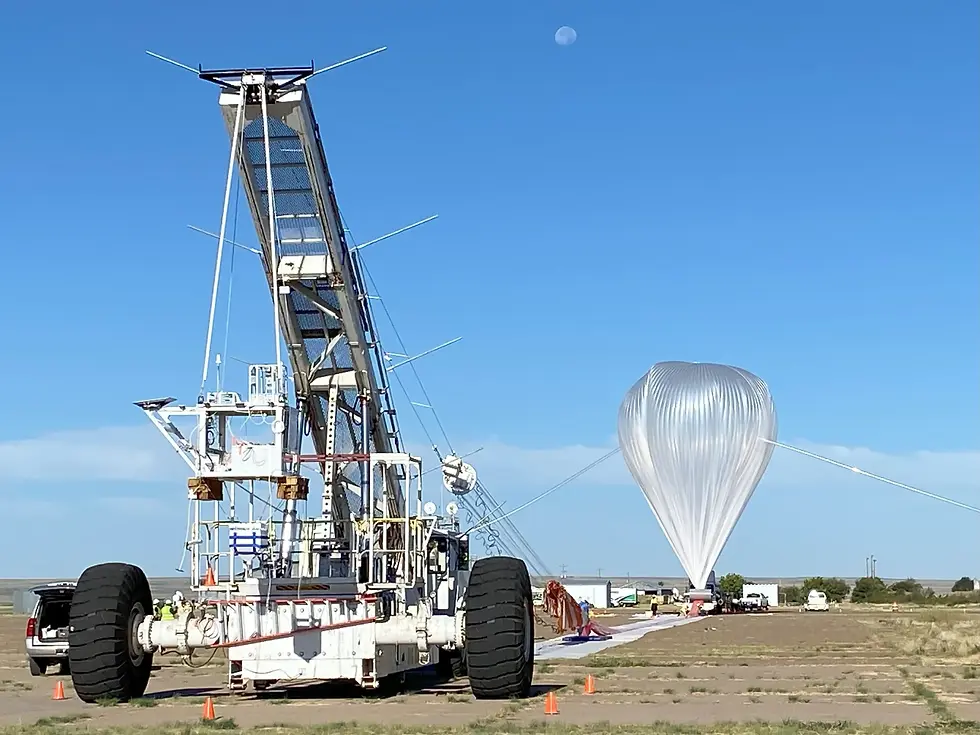
Fort Sumner, NM; Palestine, TX; and Burns, OR
NASA Scientific Balloon Program Archaeological Predictive Model Project - NASA is preparing a Scientific Balloon Program Supplemental Programmatic Environmental Assessment (PEA) to evaluate the potential environmental effects of adding a new scientific balloon launch site in Burns, Oregon, and additional improvements at the existing Fort Sumner, New Mexico and Palestine, Texas launch sites.
ERG worked with their partners at Bluestone to develop a GIS-based predictive archaeological sensitivity model for the areas where construction is proposed. These areas include the launch sites at Fort Sumner, NM; Palestine, TX; and Burns, OR. Pertinent existing documentation and studies with respect to cultural and archaeological resources at each of the three sites were compiled and evaluated. A predictive archaeological sensitivity model was developed in lieu of conducting a field survey for the proposed improvements. The model classifies areas as having low, medium, and high probability of containing significant archaeological resources.

Hays County, TX
Hays County Texas Road Bond Program On-Call Drone Videography Project - As part of the Hays County, Texas Road Bond Program, HNTB Corporation contracted ERG to capture roadway improvements through drone videography. Hays County and HNTB used these videos to showcase three of these projects for the public. From 2023 to 2025, we filmed the traffic patterns before and after construction, showcasing the enhanced traffic flow and improved safety conditions. Using cutting-edge technologies like DroneLink and Adobe Premiere Pro, we created engaging videos that Hays County published on the County website and were shared through official social media accounts.

US Army BRAC and non-BRAC Installations
US Army Futures Command Institutional Controls Management Task - From 2020 to 2022, ERG supported the United States Army’s Cleanup Program at various Base Realignment and Closure (BRAC) and non-BRAC Excess Installations across the country. The BRAC program involves transferring former Army property to other federal agencies and communities, often with restrictions known as Institutional Controls (ICs) to minimize human exposure to contamination and protect the integrity of the remedy.
To help manage these ICs, we developed a web-based, spatial application using ArcGIS Online. This application integrated geospatial data and program documents, providing query and reporting capabilities, and included a document library with relevant cleanup documentation. Technologies used included ArcGIS Pro, Spatial Analyst, 3D Analyst, Experience Builder for ArcGIS, Python, and more.

Northeastern US
Phoventus Project Sunrise Solar and Storage Facility Feasibility Study – Over the course of two months, ERG conducted GIS-based environmental constraints analysis and mapping for 34 solar farm and energy storage facility candidate sites across Maine, Massachusetts, New Jersey, New York, Pennsylvania, and Virginia. Our GIS specialists consulted hundreds of geographic constraints datasets from the states’ public archives, digitally overlaying these constraints against proposed site locations. We evaluated their potential impacts based on client-provided criteria and fed the results into a prioritization matrix.
Deliverables included over 300 maps, such as USGS topographic overviews, ownership/tax overlays, floodplains, wetlands, streams, USDA soils, local land use, natural and cultural resources, scenic or aesthetic resources, and vegetation/forested areas to be cleared. This framework helped rank the projects according to environmental constraints and shovel-readiness.

Austin, TX
City of Austin Parks and Recreation Department, Evergreen Cemetery Remote Sensing Project - ERG conducted geophysical surveys at the historical Evergreen Cemetery to support the City of Austin's efforts to expand burial capacity in two cemetery sections. Using digital dual-band Ground-Penetrating Radar (GPR), our team performed intensive geophysical remote sensing along 50-centimeter linear transects to identify potential unmarked burials and other subsurface features. The data collected from these surveys provided valuable insights that informed the City of Austin's decisions regarding the expansion of burial plots in a respectful and informed manner. By leveraging advanced geophysical techniques, we ensured that the survey was non-invasive and minimized the risk of disturbing existing graves.

St. Louis, MO
USACE - St. Louis District Mandatory Center of Expertise for Curation and Management of Archaeological Collections (MCX-CMAC) - Albeni Falls Hydroelectric Dam Archival Records Digitization Project - From February 2023 to November 2024, ERG collaborated with the St. Louis District of the USACE to digitize and inventory construction plans and documents related to the Albeni Falls Hydroelectric Dam, built in the late 1950s and early 1960s. With repairs and upgrades underway at the time of ERG’s involvement, the scanning effort was particularly timely.
Our team scanned and digitized 61 boxes of archival materials, including large format design drawings, photographs, slides, negatives, scrapbooks, and other historical documents. We conducted technical reviews of each of the 40,000+ digital scan files to ensure accuracy and compliance with USACE's standards. The digitization project significantly enhanced the accessibility and preservation of these historical records, ensuring their longevity and usability for future research and reference. Additionally, metadata was embedded in each file.
ERG’s efforts were well-received, prompting the St. Louis District’s representative to report: "The digitization of the Albeni Falls Dam archives has been a transformative project, preserving our historical records and making them accessible for ongoing research and reference. ERG’s meticulous approach and technical expertise have been invaluable in achieving this goal."

VA Salt Lake City
ERG provides Environmental Compliance Support to the U.S. Marine Corps conducting Benchmark Environmental Compliance Evaluations (ECE) at USMC installations worldwide, validates the Plan of Actions and Milestones (POA&M), conducts Environmental Management Review (EMR) data validation, ECE Team Training and assisting Headquarters Marine Corps with environmental compliance.
ECE at USMC
ERG provides Environmental Compliance Support to the U.S. Marine Corps conducting Benchmark Environmental Compliance Evaluations (ECE) at USMC installations worldwide, validates the Plan of Actions and Milestones (POA&M), conducts Environmental Management Review (EMR) data validation, ECE Team Training and assisting Headquarters Marine Corps with environmental compliance.
U.S. Army Garrison
ERG provides Environmental Compliance Support to the U.S. Marine Corps conducting Benchmark Environmental Compliance Evaluations (ECE) at USMC installations worldwide, validates the Plan of Actions and Milestones (POA&M), conducts Environmental Management Review (EMR) data validation, ECE Team Training and assisting Headquarters Marine Corps with environmental compliance.
Fort Gregg-Adams
An Installation Resiliency Plan, Oil and Hazardous Substance Contingency Plan, Tank Management Plan, updated SWPPP, an EMS Third Party Audit, and a Green Procurement Product List were services provided by ERG for comprehensive environmental compliance support for Fort Gregg-Adams, VA.